


STUDY AREAS
This is your Project Page. It's a great opportunity to help visitors understand the context and background of your latest work. Double click on the text box to start editing your content and make sure to add all the relevant details you want to share.
Low Volturno river
The low Volturno River plain is located within the Caserta province of Campania region, South Italy. Geographically it is bounded to the West by the Tyrrhenian Sea, to the North by the Roccamonfina Volcano, to the East by the Matese Massif and to the South by the Campi Flegrei caldera. The climate is Mediterranean with hot dry summers and wet winters. The most relevant lithological units outcropping in the plains are alluvial and/or of volcanic origin. Alluvial deposits are made of sand, silt, and clay derived from the Volturno River [15], while volcanic materials consist of tuffs and other volcanic products produced by explosive events of the Campi Flegrei caldera and minor events of the Somma-Vesuvio [48]. The main pyroclastic deposit is the Campanian Ignimbrite (CI), a trachytic tuff outcropping at the foothills of the carbonate reliefs with a thickness decreasing toward the coastal areas and the Volturno River because of erosion [49]. The area hosts two main aquifers which are in communication near normal faulting zones and in those areas where the CI has been strongly eroded. The regional groundwater flow is oriented from E to W, and the main recharge mechanism is due to precipitation while lateral recharge occurs from the karst and the volcanic aquifers bordering the plain [50]. The plain is characterized by intense human activities which strongly influence the land cover/use with urban and agricultural areas that are connected. Previous studies have highlighted the coexistence of both SP and AGL due to actual and paleo- seawater intrusion and intense agricultural and sub-urban activities, respectively [51].


Po Delta Plain
The Po Plain site, located along the Adriatic coast (Northern Italy), refers to the low-lying coastland encompassing the territory between the southern Venice lagoon and the Ravenna Province. The Po Plain site is part of the largest hydraulic reclamation of the Mediterranean coasts mostly lying below the mean sea level, thus, the hydrological regime is artificially regulated by a capillary network of canals, pumping stations, and gates managed by the Local Reclamation Consortia. Agriculture is the dominant land use and irrigation water is derived from the Po River, while excess water is drained from the fields and discharged through major collectors into the sea [52], with the consequence that coastal lagoons suffer from excessive nutrient load. The main hydrogeological threats that affect this territory are land subsidence, groundwater salinization, saltwater encroachment along the rivers, and pollution from agricultural activities [53]. The lowering of the piezometric level induced by the lack of recharge (due to CC) and the increasing pumping will increase the migration of the saltwater-freshwater interface inland favored by the presence of an extensive network of buried sandy paleochannels and ancient coastal ridges. Additionally, upconing of paleo-seawaters rich in NH4+, due to the presence of peaty lenses [54] originating from the maximum transgressive flooding and now trapped in the deep part of the aquifer [55], is to be expected due to heavy drainage from reclamation canals. The Po Plain constitutes an ideal study site for testing the DATASET approach and it has been selected for a variety of reasons: (i) it combines typical Mediterranean water issues (salinization processes, water scarcity, intensive irrigation needs, CC impacts, nutrients excess, etc.), (ii) it offers a typical hydrogeological setting of alluvial coastal aquifers so that DATASET results may be easily extended to similar areas, (iii) it is deeply documented with a large amount of data already available, which guarantees high chance to succeed in the fulfilment of the DATASET objectives, (iv) the long-lasting fruitful cooperation with local water managing authorities that are willing to co-design the DATASET approach, and (v) it has a high environmental value as part of the Po Delta Park
Puck Bay
The Puck Bay catchment area is in northern Poland, on the southern coast of the Baltic Sea. The use of land for agriculture dominates (51%), in addition to forests (28%), permanent meadows and grasslands (12%), and low-density urban areas (9%). The Puck Bay catchment represents a typical young postglacial landscape with relatively high relief (from -0.5 to 113.5 m above sea level). Groundwater forms a complex system with several aquifer units. Shallow groundwater occurs in small, perched aquifers and in sand lenses enclosed in moraine deposits. These aquifers do not play a key role in water supply, but they are exploited locally by farms and summer houses. Two deeper Quaternary aquifers are hosted in glaciofluvial deposits (sand and gravel) separated by a layer of moraine till. The entire hydrosystem is drained by the Baltic Sea (Bay of Puck), either directly via submarine groundwater discharge (SGD) or indirectly via streams and rivers. The Quaternary aquifers are the main source of water supply in the region [56]. The presence of pollutants in groundwater occurs locally and shows specific vertical geochemical inversion. The highest concentrations of nitrogen compounds, phosphates and potassium are observed in shallow waters, implying a local impact of agriculture, as well as an influence of municipal wastes from households and farms (e.g., poor sanitaryconditions, animal husbandry, storage, and distribution of organic fertilizers) [57]. Simulations performed with coupled SWAT-MODFLOW/MT3D model provided estimates of average annual flow rates and nitrate loads: 73 mm/y for groundwater recharge, 19.7 kg/ha/y for N-NO3 leaching from soil, 1,261 m3/h for groundwater and 1.05 kg/h for N-NO3 load discharge to Puck Bay. The main part of the N-NO3 load is discharged to the Bay of Puck from the upper aquifer which is more vulnerable to pollution migration from ground surface [52]. Preliminary assessment using the GALDIT method shows specific spatial and temporal variability of freshwater vulnerability to seawater intrusion [54]. The most vulnerable areas are situated near the coastline, where the water table is only slightly above sea level. The predicted sea level rise for the period 2081-2100 will increase vulnerability to seawater intrusion on 7% of the research area, in ice-marginal glacial valleys.


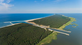
Vistula Spit
The Vistula Spit is a long, narrow, sandy peninsula on the southern coast of the Baltic Sea, with total length of 73 km (Polish part). It stretches in a north-easterly direction and separates the Vistula Lagoon (brackish water, salinity 0.2-7‰, average 3‰) from the Gulf of Gdańsk (salinity 7-8‰). The area is dominated by forest and the largest town is Krynica Morska with 1,284 inhabitants. The development of the Vistula Spit is associated with Holocene processes, which led to the creation of a well-developed system of dune ridges. The geologic setting of the study area is homogeneous, consisting of marine and aeolian sands, as well as peat formed locally as interdune peatbogs [58]. The main source of water supply is a shallow, unconfined freshwater lens, laying on the low permeable sediments occurring about -40 m above sea level. The aquifer occurs in Pleistocene-Holocene sands and the thickness is about 40 m. The entire hydrosystem is recharged by precipitation and drained by the Baltic Sea (Gulf of Gdańsk) and Vistula Lagoon. The depth to groundwater ranges from very small on the beaches to over 20 m under dunes in the central part of the spit. Locally in groundwater samples were noticed increased concentrations of ammonia (>1 mg/l), of natural origin. Groundwater is used to supply Krynica Morska, with a large uptake in summer (high tourist season) which cause salinization. The temporal variability of groundwater exploitation resulted in a large variability of chloride concentration [59-60]. At the Vistula Spit freshwater resources are extremely vulnerable to seawater intrusion, especially with unsustainable groundwater exploitation. Numerical simulations show that the freshwater/saltwater interface is very sensitive and easy to disturb due to overexploitation of groundwater.
Cape Flats
The Cape Flats have an aerial extent of approximately 450 km2 from False Bay to the South to Tygerberg and Milnerton to the North. They are found within quaternary catchments G22C, G22D and G22E (Berg-Olifants Water Management Area) with a topography typical of coastal plain and dune fields. The climate is Mediterranean with wet winters and dry summers. The Cape Flats Aquifer consists of fluvial, marine and aeolian Quaternary sedimentary deposits of the Sandveld Group, with a maximum thickness of about 55 m, underlain by impervious weathered Malmesbury and granite suite basement rocks. The unconfined Witzand formation and the semi-confined Springfontyn formation dominate the area with localized occurrences of calcrete and peaty clay lenses. Groundwater flows from NE to SW. The groundwater table is shallow (<2 m), which often causes flooding in winter. Groundwater chemistry is Na-Cl, Ca-Cl to calcium-alkaline with EC and pH ranging between 40-125 mS/m and 5.8 to 8.4, respectively. The land cover is dominated by agriculture (Philippi Horticultural Area, PHA) and urban areas (residential, industrial, business), with grassland covered sand dunes and sand mining. Groundwater is the main supply of irrigation water to PHA, especially in the dry season, and the biggest water user of the Cape Flats Aquifer. Nonetheless the PHA is an important part of the City of Cape Town’s food security with approximately 64% of land being used for food production by 30 active farmers. As a result of high spatial-temporal variability of rainfall and resulting diminishing surface water bodies, the City of Cape Town is looking to augment its municipal water supply with groundwater [61] through managed aquifer recharge and maintenance of storm water basins. Groundwater has been used by schools and hospitals for irrigation of sports grounds and the locals also find well-points a cheaper alternative to municipal water supply [62]. For this reason, it is critical that this aquifer’s integrity be maintained to ensure its sustainable use. Another dynamic to the problem is that CC and variability could potentially add more stress to the groundwater resource by reducing the much-needed rainfall recharge which helps in diluting salinity. The proximity of the ocean exacerbates the risk of salinization as it may result in seawater intrusion if groundwater levels are lowered due to increased abstraction and reduced recharge. The reduction in water quality will not only impact farmers but also residents and it will increase remediation costs if intended to be used by the City of Cape Town for water supply augmentation.


